With rapid urbanization, population growth, and evolving urban landscapes, environmental and climate challenges are intensifying, making effective and efficient urban planning increasingly critical. From shaping the physical landscape to advancing social inclusion, environmental and economic vibrancy, urban planning plays a vital role in building sustainable and resilient cities for future generations.
Spatial mapping and analysis play a central role in capturing, analyzing, and visualizing urban complexity, enabling urban planners to understand how land use, infrastructure, environment, and social dynamics interact across space and time. However, traditional geospatial tools and methods (e.g., manual surveys, mapping exercises and conventional GIS modelling) often struggle to keep pace with the speed, scale and complexity of contemporary urban change. Given limited resources, urban planners are increasingly required to adopt innovative, resource-efficient, and data-driven geospatial approaches to planning and governance.
Geospatial Artificial Intelligence (GeoAI) is an emerging interdisciplinary field that brings together artificial intelligence (AI) and geospatial analytics to extract meaningful knowledge from geospatial data. As one of the fastest developing research frontiers in spatial data science, it helps automate routine tasks and make GIS functionalities more accessible to a broader audience, including urban planning professionals with limited or no prior GIS experience.
Key GeoAI-related terms and techniques include machine learning (ML), deep learning (DL), natural language processing (NLP), agent-based computing, digital twins, computer vision, and generative AI.
GeoAI can be applied in various urban planning sectors, including land-use planning, housing and infrastructure management, mobility and transport optimization, water and waste management, public safety, disaster management, environmental and climate resilience, and administration, policy and governance. Many Asian countries have begun integrating GeoAI into urban planning processes. Selected examples include:
- The AI-driven Landslide Modelling in Nepal uses a transparent DL model to predict landslide risk in Nepal following the 2015 Gorkha earthquake. The integration of Shapley Additive exPlanations (SHAP) into the modeling workflow allows both global and local interpretations of model behavior, helping decision makers trust and understand the results, which is crucial for planning and disaster risk reduction.
- GeoAI4Water is an innovative solution that utilizes ML and DL models within a human-in-the-loop process to enhance the accuracy of mapping water resources and wastewater treatment plants (WWTPs) across It uses AI and high-quality satellite imagery (Sentinel-2 10m spatial resolution data, PlanetScope 4m spatial resolution data, BING Zoom-19 30cm spatial resolution data), and is led by HeiGIT (Heidelberg Institute for Geoinformation Technology). This initiative has helped to strengthen national datasets and demonstrates the potential of GeoAI for sustainable infrastructure planning in developing regions.
- The Digital Twin AI Platform of Luogang Park in China has built the country’s largest park-level integrated above- and below ground-level full-scenario digital twin map used in GeoAI and 3D mapping, achieving centimeter-level virtual mapping of the park’s terrain, buildings, facilities, and vegetation. It provides visual data support for sustainable optimization and innovation of smart park planning and management, urban operation and services.
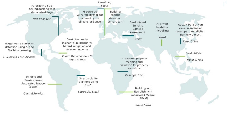
| GeoAI Case Studies
The GeoAI Toolkit provides 12 detailed GeoAI case studies to showcase how GeoAI is being applied to enhance and automate urban planning and development processes. Source: Image Adapted from the GeoAI Toolkit. |
According to Precedence Research, the global GeoAI market is projected to reach between USD 64.6 billion and USD 237.7 billion by 2030. The growth of GeoAI is being driven by technology companies providing powerful tools applied across sectors, including urban planning (e.g., Esri’s GeoAI tools integrated into GIS platforms, GeoRetina, Google’s DeepMind’s AlphaEarth, Dassault Systèmes, CityGML, India’s WebGIS Urban Sprawl Information System (USIS), among others). Annex 2 of the toolkit provides the compilation of the free and open source GeoAI tools, platforms and resources that can be adopted by urban planners in their day-to-day activities.
GeoAI brings ample opportunities and benefits for urban planning including: (i) proactive and evidence-informed decision-making processes; (ii) enhanced forecasting trends and future scenarios; (iii) strong potential to enhance the delivery and achievement of SDGs, in particular SDG 11 (Sustainable Cities and Communities); (iv) increased operational efficiency and productivity; (v) accelerated situational awareness and response; and (vi) fair participation and representation of diverse stakeholders and communities in urban planning processes.
However, along with benefits, various challenges and risks are associated with GeoAI systems, which can hinder their effective integration into urban planning processes. Key challenges and risks include: (i) fragmented datasets, and lack of reliable, high-quality geospatial data; (ii) lack of interoperability with IoT devices, digital twins, and GIS platforms; (iii) inadequate data storage or cloud services that can constrain GeoAI deployment; (iv) financial and human resource limitations; (v) governance and ethical challenges; (vi) data privacy risks; and (vii) the environmental footprint.
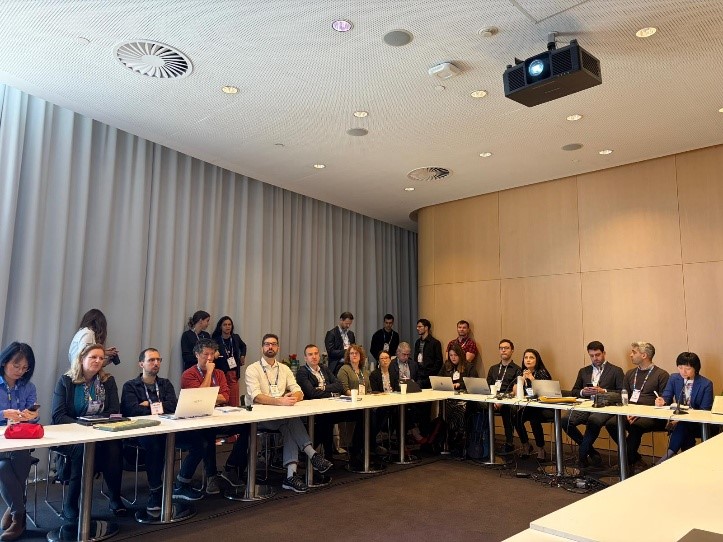
GeoAI Toolkit Validation Workshop held at the Smart City Expo World Congress, 4 November 2025, Barcelona, Spain. Participants included urban planners, city leaders and decision-makers, national governments, GeoAI experts and scientists, and technology companies developing GeoAI solutions. |
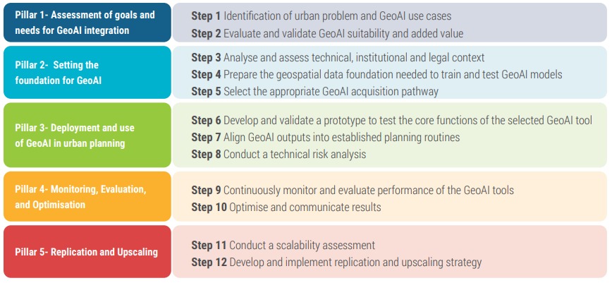
The toolkit includes a strategy for integrating GeoAI tools into urban planning to maximize benefits while mitigating associated challenges and risks. The strategy provides cities with a practical, step-by-step guide in a responsible, scalable, and people-centered way. It helps in identifying urban challenges and GeoAI needs, and in deploying and scaling operational GeoAI tools. The strategy aligns with global frameworks that specifically address smart cities, AI, and (digital) transformation in municipal governance, including ICLEI’s Green Climate Cities (GCC) methodology, UN-Habitat’s People-Centered Smart Cities flagship program, and UNESCO’s Recommendation on the Ethics of AI.
| GeoAI integration strategy and step-by-step guidance
Source: Adapted from the GeoAI Toolkit. |
ICLEI South Asia, in collaboration with ICLEI Europe and UN-Habitat, supported the preparation of the report AI for Spatial Mapping and Analysis: GeoAI Toolkit for Urban Planners. The toolkit aligns with UN-Habitat reports, including UN-Habitat’s AI & Cities: Risks, Applications and Governance and the World Smart Cities Outlook 2024. It also responds to the AI capacity needs and gaps identified in Global Assessment of Responsible AI in Cities. The GeoAI Toolkit was launched at the 4th Global Expert Group Meeting on People-Centered Smart Cities in Baku, Azerbaijan, organized by UN-Habitat in December 2025.
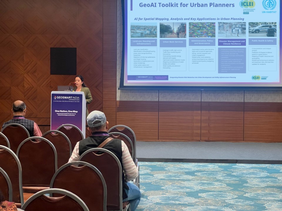
ICLEI South Asia disseminated the outcomes of the GeoAI Toolkit at the GeoSmart India 2025 Conference, New Delhi, December 2025. |
To access the GeoAI Toolkit, click here or scan the QR code below.